Self-guided audio tour in Gothenburg
Start Free on iPhone
Start free on iPhone to unlock this self-guided walking tour in Gothenburg. Hear all the stories that make it amazing, walk at your own pace, and begin whenever you want.
Your Private Tour Guide
Gothenburg wasn't built by Swedes alone. When King Gustavus Adolphus founded the city in 1621, he looked to the Dutch masters of water management to tame the marshy lands of the Göta River delta. This self-guided walking route invites you to uncover the "Dutch Blueprint" that still defines the city's heart, known as Inom Vallgraven (Within the Moat). As you explore independently, you will see how the rigid grid system and the zig-zagging moat served as a fortress against invading forces, primarily from Denmark. From the grand statue at Gustaf Adolfs Torg to the iconic "Fish Church," this neighborhood stroll reveals the layers of history beneath the pavement. You will encounter the oldest secular building in the city, Kronhuset, and walk along the Stora Hamnkanalen, once the primary artery for trade. This walking tour Gothenburg offers is perfect for those who appreciate military history and maritime architecture. You can discover the stories of German merchants and Dutch engineers at your own pace, away from the crowds. The journey concludes at the edge of the old city walls, leaving you perfectly positioned to explore the nearby Haga district or grab a bite at the harbor. It is a fascinating travel experience through the bones of a city designed for defense but built for commerce. By following this route, you will understand why Gothenburg was once considered the most heavily fortified city in Northern Europe. The mix of 17th-century brickwork and 19th-century Neo-Gothic design provides a visual timeline of the city's evolution from a military outpost to a global shipping hub. Start exploring with Zigway and see the city through the eyes of the engineers who built it.
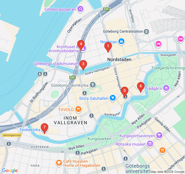
Numbers indicate the order of stops on the tour.
Welcome to the heart of Gothenburg. Standing in the center of this square is the city’s founder, King Gustavus Adolphus. Notice his finger pointing to the ground—legend says he declared 'Here, the city shall lie!' in 1621. This square was the administrative center from the start, flanked by the City Hall and the Court House. The Dutch influence is immediate here; the square was part of a strictly planned grid system designed by Dutch engineers. They were hired because of their expertise in building on marshy land. As you look around, imagine this square as the starting point for a city that was once a massive construction site of canals and wooden piles driven deep into the clay.
Just a short walk from the square stands the Christinae Church, commonly known as the German Church. It is named after Queen Christina, the daughter of Gustavus Adolphus. In the 17th century, Gothenburg was a truly international city where German and Dutch merchants held significant power. This church served the German-speaking population, who were instrumental in the city's early trade. The building you see today has survived several fires, with the current copper spire and facade reflecting 18th and 19th-century reconstructions. Its presence is a testament to the cultural melting pot that Gothenburg was during its formative years, driven by European commerce and religious diversity.
Walk along the Stora Hamnkanalen, or the Great Harbor Canal. This was once the city's main artery. In the 1600s, this canal was teeming with barges and ships unloading goods directly into the warehouses that lined its banks. The Dutch engineers designed a system of canals that mirrored those in Amsterdam, serving both as transport routes and as a way to drain the swampy terrain. While many of Gothenburg’s original canals were filled in during the 19th century to make way for roads, this one remains the most prominent reminder of the city's 'Little Amsterdam' roots. Take a moment to appreciate the symmetry and the sturdy stone walls that have held the city together for centuries.
Tucked away behind the modern streets is Kronhuset, the oldest secular building in Gothenburg, completed in 1642. This red-brick structure was built as an artillery warehouse for the Swedish military. Its design is functional and sturdy, with thick walls meant to withstand the weight of heavy cannons. A pivotal moment in Swedish history occurred here in 1660, when the Swedish Parliament met in this building and five-year-old Charles XI was proclaimed King following the sudden death of his father. Today, the surrounding small buildings, the Kronhusbodarna, house craft shops and a cafe, offering a rare glimpse into the city's pre-industrial atmosphere and 17th-century craftsmanship.
Kungsportsplatsen, or the King's Gate Square, marks the site where one of the main entrances to the fortified city once stood. Until the mid-19th century, Gothenburg was surrounded by massive stone walls and a zig-zagging moat. The King’s Gate was a heavily guarded portal that controlled entry into the city. When the fortifications were demolished to allow the city to expand, this area transformed into a bustling social hub. Today, you can see the statue of King Charles IX on horseback, known locally as 'Kopparmärra.' This spot serves as the bridge between the old historic core 'within the moat' and the newer 19th-century boulevards that lie beyond.
At Bastionsplatsen, you are standing on the edge of the old world. This area provides one of the best views of the remaining zig-zag shape of the city's moat. The unusual angles were not for aesthetics; they were a military necessity. The bastions allowed defenders to fire upon attackers from multiple directions, ensuring there were no 'blind spots' along the walls. While the high stone walls are gone, the water still follows the original 17th-century defensive perimeter. It is a peaceful spot today, but 350 years ago, this was a high-security zone of cannons, guards, and earthworks designed to keep the Danish navy at bay.
The final stop is Feskekörka, the 'Fish Church.' Built in 1874, it isn't actually a church but an indoor fish market. The architect, Victor von Gegerfelt, was inspired by wooden Norwegian stave churches and Gothic stone cathedrals. He wanted to create a grand, pillar-free space that would honor the city's most important commodity: seafood. The building was an experimental feat of engineering for its time. It sits right on the edge of the moat, allowing fishermen to unload their catch directly at the market. It stands as a symbol of Gothenburg’s transition from a military fortress to a world-class maritime and fishing port, blending heritage with daily local life.
Start Free on iPhone
Explore “The Dutch Blueprint: Canals and Fortifications” with your very own Private Tour Guide with Zigway. Start free on iPhone, skip the large group and the fixed routes, and hear the city come alive as you go.
Your Private Tour Guide
Don't miss the good stuff
Explore Freely
 Easy
EasyGothenburg, Sweden
Discover Gothenburg’s maritime flavors on this self-guided walk through historic market halls and iconic seafood landmarks.
 Moderate
Gothenburg, Sweden
Discover Gothenburg’s maritime soul on this self-guided walk from the historic Central Station to the scenic riverfront at Stenpiren.
 Easy
EasyGothenburg, Sweden
Explore Gothenburg's elegant academic district, featuring grand 19th-century stone architecture and the iconic cultural hub of Götaplatsen.
 Easy
EasyGothenburg, Sweden
Explore Gothenburg’s historic wooden houses, legendary giant cinnamon buns, and panoramic fortress views on this self-guided neighborhood stroll.
 Easy
EasyNairobi, Kenya
Explore Nairobi's architectural evolution from colonial-era landmarks to iconic Brutalist skyscrapers on this historic self-guided walking route.
 Easy
EasyNairobi, Kenya
Discover Nairobi's iconic skyline on this self-guided architecture walk through the CBD’s most famous modernist and Brutalist landmarks.
 Easy
EasyKrakow, Poland
Explore the prestigious Jagiellonian University district, featuring Neo-Gothic architecture, Baroque churches, and Krakow's hidden scholarly gems.
 Easy
EasyKrakow, Poland
Explore the historic heart of Kazimierz on this self-guided walk through synagogues, ancient cemeteries, and vibrant squares.
 Easy
EasyStockholm, Sweden
Taste your way through Stockholm's premier food halls and historic cafes on this flavor-focused self-guided walk through the city's heart.
 Easy
EasyStockholm, Sweden
Discover Stockholm's naval legacy on this peaceful self-guided walk through historic barracks, grand admiralty houses, and scenic island fortresses.
 Moderate
Stockholm, Sweden
Walk the gritty, atmospheric streets of Södermalm and discover the real-life locations of Stieg Larsson's Millennium trilogy.
 Easy
EasyStockholm, Sweden
Explore the world's longest art gallery on this self-guided walk through Stockholm’s most stunning cavernous subway stations.